


BULLETIN
Tropical Storm Philippe Intermediate Advisory Number 5A
NWS National Hurricane Center Miami FL AL182017
800 PM EDT Sat Oct 28 2017
...PHILIPPE MOVING OVER THE STRAITS OF FLORIDA...
...HEAVY RAINS OCCURRING OVER CENTRAL CUBA AND SPREADING
NORTHWARD ACROSS THE FLORIDA KEYS AND SOUTH FLORIDA...
SUMMARY OF 800 PM EDT...0000 UTC...INFORMATION
----------------------------------------------
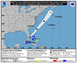
LOCATION...23.7N 82.5W
ABOUT 50 MI...80 KM N OF HAVANA CUBA
ABOUT 75 MI...120 KM SW OF KEY WEST FLORIDA
MAXIMUM SUSTAINED WINDS...40 MPH...65 KM/H
PRESENT MOVEMENT...N OR 5 DEGREES AT 28 MPH...45 KM/H
MINIMUM CENTRAL PRESSURE...1002 MB...29.59 INCHES
DISCUSSION AND 48-HOUR OUTLOOK
------------------------------
At 800 PM EDT (0000 UTC), the center of Tropical Storm Philippe was
located by surface observations, radar data, and satellite images
near latitude 23.7 North, longitude 82.5 West. Philippe is moving
toward the north near 28 mph (45 km/h). A turn toward the northeast
is expected during the next several hours, followed by a faster
motion toward the northeast on Sunday and Monday. On the forecast
track, the center of Philippe will move through the Straits of
Florida this evening, and move across the Florida Keys or the
southern tip of the Florida peninsula overnight, and across the
northwestern Bahamas Sunday morning.
Maximum sustained winds are near 40 mph (65 km/h) with higher gusts.
Strengthening is forecast during the next 48 hours.
Tropical-storm-force winds extend outward up to 105 miles (165 km)
mainly to the east and southeast of the center.
The estimated minimum central pressure based on surface observations
is 1002 mb (29.59 inches).
HAZARDS AFFECTING LAND
----------------------
South Florida, including the Keys: 2 to 4 inches with isolated
maximum totals of 6 inches through Sunday. These rainfall totals
may produce flash flooding, especially in urbanized areas.
WIND: Tropical storm conditions are likely occurring in the
warning area across Cuba. Tropical storm conditions are expected to
occur in the warning area later tonight across the northwestern
Bahamas. Tropical storm conditions are possible across the upper
Florida Keys and southeast Florida overnight, and in the central
Bahamas by Sunday morning.
TORNADOES: A couple of brief tornadoes are possible across portions
of South Florida and the Florida Keys this evening.
NEXT ADVISORY
-------------
Next complete advisory at 1100 PM EDT.
Results 1 to 3 of 3
Threaded View
-

 Tropical Storm Philippe Hitting Keys
10-28-2017 09:22 PM
Tropical Storm Philippe Hitting Keys
10-28-2017 09:22 PM


Posting Permissions
- You may not post new threads
- You may not post replies
- You may not post attachments
- You may not edit your posts